Bridges That Dare You to Cross
Let’s talk bridges—again. When I first dipped into this topic, I had no idea how many life-threatening crossings existed around the world. It’s truly fascinating… and a little terrifying.
Here are a few more that push the limits of courage and engineering:
🌪️ Hussaini Suspension Bridge — Pakistan
A landslide wiped out the original 1968 bridge, and in its place rose a daring suspension of wooden planks and rope—minimalist, precarious, and unforgettable. Picture this: 635 feet of rectangular wooden planks, strung together by just six ropes. To reduce wind vibrations, the planks are spaced apart—meaning you’ll be stepping over gaps as you cross. In 2013, Condé Nast Traveler named it one of the most dangerous bridges in the world. No surprise there.

🪵 Vitim River Bridge — Russia
This one sets the bar for sheer nerve. A single-lane wooden bridge with no railings, perched over a frigid Siberian river. Add in rotting wood and icy conditions, and you’ve got a recipe for second thoughts. It’s not just a crossing—it’s a dare.

🌊 Carrick-a-Rede Rope Bridge — Northern Ireland
Spanning 66 feet and suspended 98 feet above jagged rocks, this rope bridge connects Carrick Island to the mainland. Strong winds and crashing waves make the crossing a heart-pounding experience. Some tourists are so shaken they need to be ferried back by boat. Would you brave it?

🐒 Monkey Bridges — Vietnam
Crafted from bamboo and used daily by locals, these narrow, unsupported bridges are a test of balance and bravery. Tourists often hesitate—but if you’re feeling bold, they offer a truly authentic challenge. Think you’ve got the nerve?

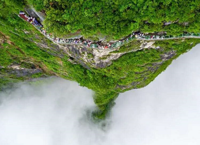
🧗 Tianmen Mountain Glass Skywalk — China
Afraid of heights? Timid? Have a heart condition? Then this one’s not for you. Built along high cliffs, these glass skywalks are painted green to reduce panic—but even that doesn’t stop knees from buckling. The views are breathtaking, if you can keep your eyes open. If you go, I’d love to hear how you fared.
More to Come…
There are countless bridges out there that test the limits of human courage. I won’t get to them all—but I’d love your help. Have you crossed a bridge that belongs on this shortlist of terror? Drop me a note and let’s add it to the adventure.


 The Hana Highway runs through a rainforest


 A pair of caribou raced across a frozen river as we passed by. At one stop some mushers came on to talk to us about dog sledding. About that time someone spotted a coupled of grizzly bears fresh out of hibernation. They were just tiny dots in the distance. After the first excitement of the train ride wore off it began to get a bit long. Lots of people used the time to nap. The 9 1/2 hour trip seemed endless. Probably because it stretched to 11 hours before we pulled into the station in Denali.
 Off the train and onto a bus


 The Return