Natural Wonders of the USA part 13

Natural Wonders Part 13

Wow We are headed into the home stretch on the Natural Wonder’s list! We’re at #45!  Only 5 more to go! As the saying goes, so much to see, so little time. We left off at Wisconsin and the Cave of Mounds. Which state is next and what’s the wonder?

#45 – Maryland – Muddy Creek Falls

It’s not as impressive as some of the other falls on the Natural Wonders list at only 53 feet but Maryland’s wonder is Muddy Creek Falls. You’ll find it in Swallow Falls State Park.  I think  what may be the most impressive thing about this pretty little falls is the surrounding tree growth. The Hemlock trees around the falls are as much as 300 years old. I’ve visited Maryland but not this Wonder.


Muddy Creek Falls | The Muddy Creek Falls in Swallow Falls S… | Flickr

Photo credit- Flickr


#46  Missouri – Cuivre River
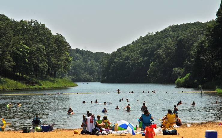
Cuivre River State Park | Missouri State Parks

Photo from internet

Looking for the Ozarks in northern Missouri? Cuivre River State Park is one of the state’s largest and most rugged parks!

Cuivre River State Park lends a wilder, Ozarkian flavor to the otherwise predominately agricultural landscape of northern Missouri. Although not far from St. Louis, the park is a nature lover’s paradise. It is an outdoor delight to stroll through the park in the spring when flowering dogwood is in bloom or in the fall when the trees are ablaze with autumn colors. (I stole this description from the Cuivre State park  web page. Since I haven’t been there myself I couldn’t think of any better way to describe it to you.)


#47 – Indiana – Indiana Dunes State Park

Now this gets my attention. I missed out on Great Sand Dunes in Colorado so maybe I can see some sand dunes if I get to Indiana. There are 3 miles of dunes along Michigan Lake in Indiana Dunes State Park. And 2000 acres waiting to be explored. Large sand dunes, located beyond the entire shoreline, have taken thousands of years to form, and tower nearly 200 feet above Lake Michigan. FYI, the State Park and the National Park are not the same thing. 
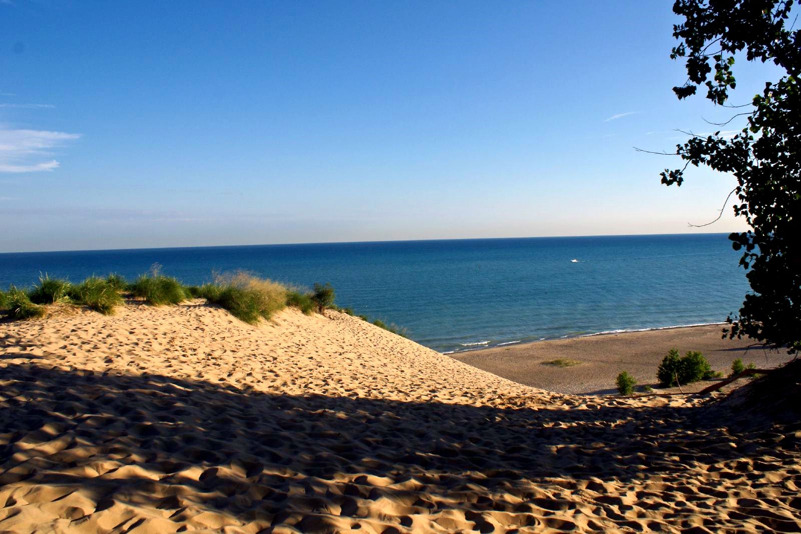
File:Indiana Dunes.jpg - Wikimedia Commons

Photo Credit- Wikimedia Commons

Next time In our Natural Wonders series

We’ll wrap up. We still have Texas and California and unless I have counted wrong I’m missing one more state. I’ll need to review the list. Did I miss a state or just lose count? What do you think will be the Natural Wonders for Texas and California?

Across the Canadian Border

The Rugged Canadian Wilderness

Once across the Canadian border we were able to see both the beauty and the wildness of the Canadian Rockies.  And it was cold here too. Lots of snow and ice.

Ice covered lake

At the Summit Rest Area we picked up our passports with our Yukon Stamps, grabbed a quick hot chocolate to ward off the cold then returned to the outside to explore the Yukon Suspension Bridge over the Tutshi River.

Crossing the Suspension Bridge

Yukon Suspension bridge

Tutshi RiverOK I’ll admit I am a bit of an adrenaline junky. More so when I was younger and I trusted my body a bit more but I still like things that make my heart pound a little. Crossing the Yukon Suspension Bridge did that. Stopping in the middle as it swayed and bounced so I could take pictures of the river was even more of a jolt. But it’s worth it. The Tutshi River was a raging maelstrom of white water. Its almost impossible to believe that the gold rush miners tried to raft down this river with their supplies.

Story Boards tell the Tale

Between the rest area and the suspension bridge were a series of story boards. They told  the miners’ tale of their hardships and extreme toil. Each miner was required to bring a year’s supply of food by the Canadian government to prevent starvation. In all, their equipment weighed close to a ton!

fog bound gulchThe Return

We loaded into buses for our return to Skagway. The fog continued to linger as the bus followed the same route as the train had in the morning. We were on our way to wrap up the trip with a “Garden Party” lunch. The lunch was forgettable as I can’t remember much about it now but I do remember the photographs of huge rhubarb leaves. The long hours of sunlight make up for the short growing season.


Garden Party

Back to the Ship

After the lunch it was back to the ship. As I recall we skipped any afternoon excursions to relax on our balcony.

One More Waterfall

Lower Falls Yellowstone River

I’ve got one more Waterfall on my list of stops for this day.  Lower Falls on the Yellowstone River is known as the Grand Canyon of the Yellowstone. I need to warn you, I didn’t fall in or get chased down to the bottom by a bear , or go over them in a barrel. I’ve noticed that I get far more “likes” when something scary happens to me. Unfortunately this will be disappointing for my thrill seeking readers. Its just an absolutely beautiful waterfall.

Lower Yellowstone Falls

Norris to Canyon Junction

I’m saving Norris Basin for my next Yellowstone trip so as my friends in the white Navigator turned left I continued on toward Canyon Village. There were a few more critter jams. The bison were taking their time crossing the road. At one critter jam the wait was over 20 minutes. I couldn’t see what was going on but once we started moving it was apparent. It was a huge herd of bison.  At Canyon Junction I made a right and soon spotted the parking area for the Lower Falls. A boardwalk leads out to a platform known as Lookout Point.

Lower Falls on the Yellowstone River

Red Rock Point

I really need to get over my back injury because on my next trip the trail to Red Rock Point is on my bucket list. The trail is only about a mile round trip but it’s steep! And I mean very steep! The bottom of this trail is consider the best place to experience the Lower falls and to get the best photos. Sadly,  I definitely wasn’t up to that hike this trip.

Red Rock Point

Inspiration Point and The Upper Falls

Another reason to return is that I didn’t see the upper falls at all. The road to Inspiration Point was closed and I wasn’t even aware that there was a side road called North Rim Drive. From what I’ve heard since my trip this allows for close views of the upper falls. Lower falls is the more spectacular if you base this assumption on size alone.  The Upper falls drops 109 ft. Pretty impressive by eastern standards but Lower falls drops 308 ft! Yes, I definitely want to explore this area more next trip.

Lower falls throws up spray

High Water at the Lower Falls of the Swift River

High Water at the Lower Falls

After leaving Sabbaday Falls I headed east on the Kancamagus Highway. The Swift River runs parallel the the Kancamgus  on your left as we headed down the mountains. The water was high and really rushing. I actually drove right by the Lower Falls because I wasn’t expecting to be able to see them right there from the road. A but further down the Kanc I found a place to turn around so I could back track.

http://dustyroadsphotos.zenfolio.com/p247808837/h892e6ad4#h892e6f2f

Kayaking The Swift River

On my way back to the Lower Falls I passed a trail head with a number of trucks and vans parked by the road. Some had kayaks piled next to them but I didn’t see anyone around.  A couple of corners later I could see the  Lower Falls ahead and the kayaks were explained. There were at least a half dozen brightly colored kayaks being put in just below the Falls. They must be putting in here then kayaking downstream to meet the vans. I hurried to park because I wanted to get some pictures but in the few minutes  it took me to pull in the kayakers were long gone and out of sight.

http://dustyroadsphotos.zenfolio.com/p247808837/h892e6ad4#h892e6ad4

Lower Falls Picnic area

The parking area is beautifully maintained, fully paved and lined. There is a large visitor center with restrooms. The trails are really just short paths over to the river bank. A large wooden deck extends over the river providing a great view of the falls. During low water in the summer people swim here. But clearly the wild water from the spring run off makes it too cold and the current too strong for swimming at this time of the year.

http://dustyroadsphotos.zenfolio.com/p247808837/h892e6ad4#h892e6add

If You Go

The lower falls are not a world class waterfall by any stretch of the imagination. They are made up of a series of ledges and steps. In low water there are lots pools and beaches and people flock here to swim. It was fun to see the water volume giving these quiet, gentle falls a bit of life and energy. Definitely needs a return trip in summer or fall to see a different side of this popular destination.

http://dustyroadsphotos.zenfolio.com/p247808837/h892e6ad4#h892e6ad9

Wisconsin

Land of the Cheese. I’m going to say yes but I probably should say no. I didn’t get much sight seeing done as I was only there a few days. I think I may have touched on the visit when talking about Illinois and Chicago O’hare International Airport. So rather than repeat myself; let’s just say it’s the journey, not the destination!

cheese

My brother retired from the Navy at the base in Wisconsin. He was stationed there and living in Kenosha so I had the chance to fly in for the ceremony and visit his home and that was about it. I’m sure there’s so much more to the state so let’s see what I can dig up.

Navel-Station-Great-Lakes

Wisconsin shares it’s shores with Lake Michigan and Lake Superior, 2 of the largest of  the 5 great lakes. In size Lake Superior is #1, Lake Michigan is #3, right behind Lake Heron.

Lake-Superior

Seems to me Lake Superior deserves a visit. It’s the largest freshwater body in the world and a great place to visit would be The Apostle Islands. 22 islands strewn over 450 square miles, they range from tiny Gull island (3 acres) to 10,000 acre Stockton Island.

apostleBlog23

Heading south from the Great Lakes you’ll find the famous cheese country from Monroe to Mineral Point. Here the rolling hills and river valleys attracted dairy farmers starting in the 1800’s. Today it is the heartland of  Wisconsin’s dairyland where cheese making remains a generations-old fine art.

dairy

In Ontario, Wisconsin you can explore the “Driftless area”  all  serpentine valleys, crooked rivers, craggy bluffs and limestone. The Kickapoo River best characterizes this geology. Sometimes called the “crookedest river in the nation”. One of the oldest river systems in the world, the Kickapoo winds for 120 miles to cover a 65 mile distance. It’s a lazy spring-fed river of easy paddling except during the spring run off.

B0013P 0026

Running from Prairie du Chien to Prescott is the Great River Road or at least part of it. The 250 miles is only a fraction of the whole byway running the length of the Mississippi River. This stretch slaloms between the Mississippi and it’s towering bluffs. The road will take you through sleepy river towns, past busy barge traffic, braided backwaters, wildlife preserves   and birds, birds, birds. This is part of the Mississippi Flyway. More than 40% of the Nation’s waterfowl and shorebirds pass this way.

greatriverroad-20133

In the southern end of the state, not far from Chicago, Illinois is Lake Geneva. The area has a resort-like feel and attracts vacationers from all over. The lake is a pristine spring-fed lake 22 miles in circumference. Being only 10 miles from the state line you can see how it would attract city weary residents of Chicago.

Lake-Geneva

There’s more, from the North Country to Circus World, Amish settlements  to Madison’s Dane County Farmers’ Market but I’ll leave some of that for another time.

The count is now 21/ 28. Only one more state to go.